Appendix — Concluding Illustration — Ezekiel 48
The two representations show the schematic arrangement and a possible geographical application. The accompanying explanations and disclaimer form part of the illustration.
Important — How to Read the Original Illustrations
The following illustrations are reproduced without alteration from the original Dutch edition. To preserve their cartographic content, schematic arrangements, annotations , the Dutch text within the images has not been replaced. The English translations immediately following each image should be read alongside it. Any reference to a scriptural translation in the English edition follows the edition’s stated source conventions; the source image itself remains unchanged.
Illustration 2 — The Division of the Land According to Ezekiel 48
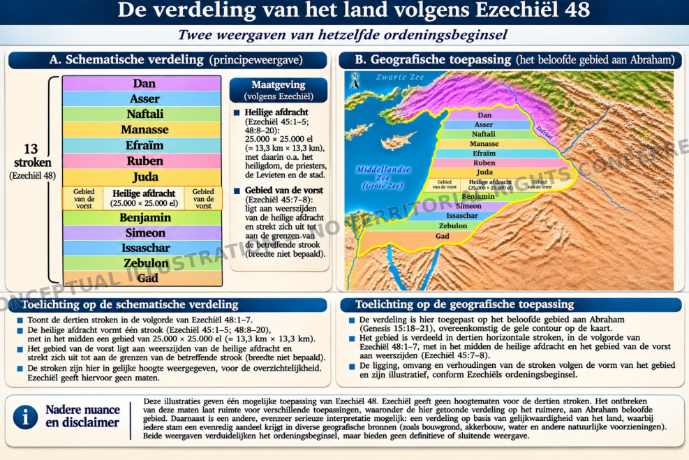
Two representations of the same principle of territorial arrangement.
English Translation of Illustration 2
A. Schematic Division (Illustration of the Principle)
Thirteen strips (Ezekiel 48). From north to south: Dan, Asher, Naphtali, Manasseh, Ephraim, Reuben, Judah, the sacred allotment with the prince’s land on both sides, Benjamin, Simeon, Issachar, Zebulun and Gad.
Dimensions (According to Ezekiel)
- Sacred allotment (Ezekiel 45:1–5; 48:8–20): 25,000 × 25,000 cubits (approximately 13.3 km × 13.3 km), including, among other things, the sanctuary, the priests, the Levites and the city.
- The prince’s territory (Ezekiel 45:7–8): located on both sides of the sacred allotment and extending to the boundaries of the respective strip (width not specified).
Explanation of the Schematic Division
- Shows the thirteen strips in the order of Ezekiel 48:1–7.
- The sacred allotment forms one strip (Ezekiel 45:1–5; 48:8–20), with an area of 25,000 × 25,000 cubits (approximately 13.3 km × 13.3 km) in its centre.
- The prince’s territory lies on both sides of the sacred allotment and extends to the boundaries of the corresponding strip (width not specified).
- For clarity, the strips are depicted with equal heights. Ezekiel provides no measurements for their heights.
B. Geographical Application (The Territory Promised to Abraham)
Map labels: Black Sea; Mediterranean Sea (Great Sea); Euphrates; the prince’s territory (on either side); sacred allotment (25,000 × 25,000 cubits). The twelve tribal names follow the same north-to- south order shown in panel A.
Explanation of the Geographical Application
- The division is applied here to the territory promised to Abraham (Genesis 15:18–21), corresponding to the yellow outline on the map.
- The territory is divided into thirteen horizontal strips in the order of Ezekiel 48:1–7, with the sacred allotment and the prince’s territory on either side in the centre (Ezekiel 45:7–8).
- The location, extent and proportions of the strips follow the shape of the territory and are illustrative, in accordance with Ezekiel’s principle of arrangement.
Further Nuance and Disclaimer
These illustrations present one possible application of Ezekiel 48. Ezekiel does not specify the heights of the thirteen strips. The absence of such measurements leaves room for different applications, including the division shown here of the broader territory promised to Abraham. Another equally serious interpretation is a division based on the equitable value of the land, with each tribe receiving an equal share in diverse geographical resources (such as building land, arable land, water and other natural provisions). Both representations clarify the principle of arrangement but are neither definitive nor exhaustive.
Source references: Ezekiel 45:1–8; 48:1–35; Genesis 15:18–21. In the English edition, Tanakh citations follow JPS 1917. The Dutch source illustration remains unmodified.